
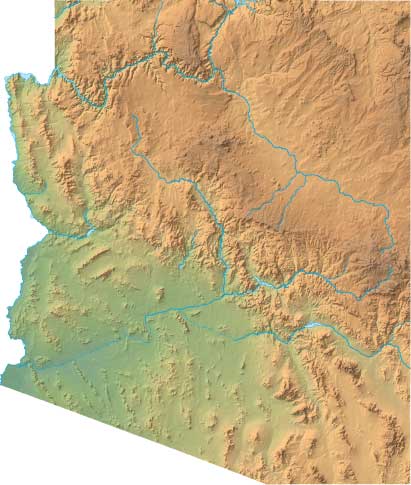
Arizona Relief Map
Static Arizona Relief Map
Interactive Arizona Relief Maps
The interactive relief map choices include a standard Google terrain map and an enhanced Google terrain map with Street View capabilities. To zoom in or out on either of these Arizona maps, click or touch its plus (+) button or its minus (-) button, respectively. To pan either map in any direction, simply swipe it or drag it in that direction. To display either of these Arizona terrain maps, click or touch one of the following menu options.
Arizona's highest mountain is Humphreys Peak, whose peak is 12,633 feet above sea level. The largest lake in Arizona is Lake Roosevelt. If you are planning a visit to Arizona, please see Visit Arizona, the official state tourism site, where you can find a wide range of travel and vacation information. For information about Arizona history and recreational activities, visit the following National Park sites.
Arizona National Parks
- Canyon De Chelly National Monument
- Casa Grande Ruins National Monument
- Chiricahua National Monument
- Coronado National Memorial
- Fort Bowie National Historic Site
- Glen Canyon National Recreation Area
- Grand Canyon National Park
- Hohokam Pima National Monument
- Hubbell Trading Post National Historic Site
- Juan Bautista de Anza National Historic Trail
- Lake Mead National Recreation Area
- Montezuma Castle National Monument
- Navajo National Monument
- Old Spanish National Historic Trail
- Organ Pipe Cactus National Monument
- Parashant National Monument
- Petrified Forest National Park
- Pipe Spring National Monument
- Saguaro National Park
- Sunset Crater Volcano National Monument
- Tonto National Monument
- Tumacacori National Historical Park
- Tuzigoot National Monument
- Walnut Canyon National Monument
- Wupatki National Monument
Copyright © 2005-2024 State-Maps.org. All rights reserved.
Arizona-Map.org is a State Maps reference source.
To facilitate browsing, certain external links will open in new windows.
Arizona-Map.org is a State Maps reference source.
To facilitate browsing, certain external links will open in new windows.